
products categories

contact us
- If you have questions, please contact us, all questions will be answered
- Tel : 18030236818
- Fax : +86-592 5237901
- Email : dexing@china-dexing.com
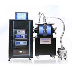
Hall Effect Measurement System
For the first time, geomagnetic field total factor aerial survey was realized
Taking the innovative route, the comprehensive aerial geophysical survey technology in China has made comprehensive progress. On May 30, Xiong Shengqing, chief engineer of China Aero Geophysical Survey and Remote Sensing Center for Natural Resources, said in a special speech on the progress of geophysical exploration technology that such progress is reflected in the first realization of geomagnetic field total element aerial survey and other breakthroughs.
For the first time, total elements (7) of geomagnetic field aerial survey was realized, and a new era of total parameters (19) of geomagnetic field aerial survey was opened. We have independently developed an all-digital aeromagnetic general field survey system, an aeromagnetic all-axis gradient survey system, and an aeromagnetic three-component survey system, which was put into practice in 2018, with a physical workload of 8,937.1 km.
Airborne gravimetry and gradient measurement break through the blockade and fill the blank in China. It has mastered the theories, methods and key technologies related to aeronautical gravity technology system, developed "strapdown + inertial navigation" and "strapdown + inertial navigation + platform" aeronautical gravimeter, and integrated aeronautical gravity and gravity and magnetic survey system of various flight platforms. The measurement accuracy and application level have reached the international advanced level and filled the gap in China. The airborne gravity survey system has been established to effectively serve the exploration of oil and gas resources and basic geological research, with an annual airborne gravity survey capacity of more than 100,000 kilometers, realizing the leap-forward development of China's airborne gravity survey technology.
Adhere to the technical route of combining independent research and introduction, the aviation electromagnetic survey has established a relatively complete technical system of aviation electromagnetic survey in China, which has reached the international advanced level.
Airborne radioactivity survey, independently developed the full digital airborne gamma spectrum exploration technology system, its technical indexes are better than foreign products, for China's uranium exploration and nuclear environment monitoring to provide technical and equipment support.
China has developed the first integrated aeromagnetic, magnetic and remote sensing exploration system in China, which can acquire four parameters at the same time and increase the exploration efficiency by two to four times, forming an integrated aeromagnetic, electromagnetic and gamma spectrum exploration system with independent intellectual property rights.
We have independently developed the first set of geophysical data processing and interpretation software platform in China with international advanced level. The platform consists of 682 functional modules, realizing the rapid processing and interpretation of gravity, magnetic force, electromagnetic force, radioactivity, as well as the full parameter and whole process on the same platform. At present, more than 1000 sets of the software have been popularized throughout the country, breaking away from the long-term dependence on imported data processing software in airborne geophysical exploration, and driving the comprehensive progress in data processing and interpretation of geophysical exploration in China.